
Autor*innen: Julien Siebert, Sarah Brandt.
Kategorie: Smart Cities.
Introduction
Current trends regarding demographic change, increasing urbanization, climate change, and changing work habits, coupled with the constraints of cities, such as competition between different uses of space or resource constraints (water, energy, money, skills), mean that cities increasingly require information exchange between a growing number of different systems and services to address the problems they are facing.
Let’s consider the following examples:
- evaluate and plan water-saving strategies, it is necessary to know the status of the city’s water supplies (public and private). This requires information on public water infrastructure, groundwater, rivers, and lakes, as well as private water reservoirs (i.e., cisterns).
- To plan and evaluate renewable energy strategies such as the installation of photovoltaic panels on building roofs, it is necessary to know the energy-producing potential of each building. This requires knowing the position of the buildings, the sunshine rate each building receives throughout the year, the degree of roof inclination, and whether any panels have already been installed.
- Strategies for biodiversity protection and climate adaptation require, among other things, knowledge about the state of plants and trees in the city. Several types of information are useful. Among other things, one might be interested in knowing which trees or plants are suffering from drought. Climatic information, the position of the plants (e.g., are they exposed to intense heat due to the presence of buildings?), as well as the color of the leaves are all potentially useful data points provided by different systems.
Smart cites are complex due to the high number of stakeholders and domains within the city. With increasing digitalization in cities, the amount of data also increases. Additionally, innovative technologies and new ways of gathering data via sensors and drones have become more common, which raises the need for more collaboration and communication in the city. New tools for analyzing and simulating city processes further make work more efficient through data-driven decisions. Currently, cities are in the process of identifying the various sources of information that are relevant to their processes and are trying to bring them together.
This need for information exchange has long been recognized. Already existing smart city strategies have paved the way for emerging data platforms to provide relevant information to the stakeholders that need it, for example the project “Connected Urban Data Architecture” (CUDA) in Freiburg, Germany [https://smartcity-germany.de/freiburgimbreisgau/]. In smart cities, data platforms are of central importance, as they connect data from different sources within the city. Still, data silos exist in cities, which hamper the integration of data and services necessary to perform interdisciplinary tasks. Another expected benefit of such platforms is that they enable new services to be created that cannot be realized without such a platform. For example, the platform “Gieß den Kiez” informs users about the water needs of trees in their neighborhood. Users can adopt trees and tick them off when they have watered them. The platform “Mundraub” enables users to tag trees by species and discover where fruits and plants can be harvested in the city. The potential of city plants and trees can be further expanded by integrating even more data. For example, tree databases can be combined with satellite or aerial data to visualize them on a map, evaluate the green potential of the city, or enrich services like Mundraub. These services could in turn help city planners and stakeholders work together and foster communication, a sense of community, and citizen participation in urban life and in municipal decisions about their environment.
Another recognized trend is the need for and increasing use of digital twins. Digital twins can be defined as a digital representation of physical assets that exceeds the information level (i.e., the transmission of sensor data) by adding a functional layer that allows actions in the physical world to be triggered from their virtual mirror. To use a simplistic example: A “smart” sprinkler can physically indicate its state (on or off) and measure the amount of water used over time (through a metering system), but it can also provide a software interface that can turn it on or off remotely and monitor it. Smart cities are currently working on digital city twins (see for instance, the “5GAPS” project in Hanover, Germany) by understanding their characteristics and needs, identifying use cases for implementing them, and determining their potential. The idea is to connect data and systems in order to deal with city challenges. Even though the benefits for cities are clear, many challenges still exist – within the city, but also with the technology itself – which need to be overcome before systems can be integrated, for example as a city’s digital twin.
Towards city systems of systems
The increased availability of data platforms and digital twins allows systems of systems to be established. A system of systems is a constellation of different systems that cooperate (e.g., through their digital twins) to achieve a goal that none could achieve alone (Gorod et al. 2008).
This opportunity raises two questions. First, why should one implement and use such systems of systems – in other words, what could we do with them and how do they benefit us? Second, if these types of systems are necessary and useful, what research in software engineering is yet to be carried out so that such systems can achieve their goals while respecting the current constraints in terms of data use, automation of decisions, and impact on the environment and on energy consumption?
Imagining and predicting what a system of systems could do without having all of its components already available is a difficult task. In the domain of smart cities, only few examples currently exist that demonstrate their potential.However, by extrapolating from existing similar types of systems such as digital ecosystems (Koch, Krohmer et al. 2022), we can navigate the realm of what is possible without being too futuristic or naïve.
By letting other systems know what functionality a system provides, what resources it needs, and when and where that system might be available (i.e., what capabilities it has), systems can be (dynamically) rearranged for or reused in multiple contexts, and (physical) systems that are inactive most of the time can find a second use. For example, a market square or a supermarket’s parking lot is a space whose intensity of use continually changes. The parking lot may be empty on Sundays, and a market square may only be used once a week for an actual market with booths. These spaces are sometimes used for other purposes: a flea market in an empty parking space on the weekend, or a qi gong lesson in the market square when the weather permits. Having a digital representation of these spaces (as “assets”) with an interface that allows people to see when they are being used, for what purpose, and to request and reserve a time slot (as one would for a meeting room), allows for a multipurpose reuse type approach. Similarly, the data collection of systems can be enhanced to support additional purposes. Drones that take pictures to monitor mobility could, in parallel, provide useful data on the health of trees, rooftop use, or surface types.
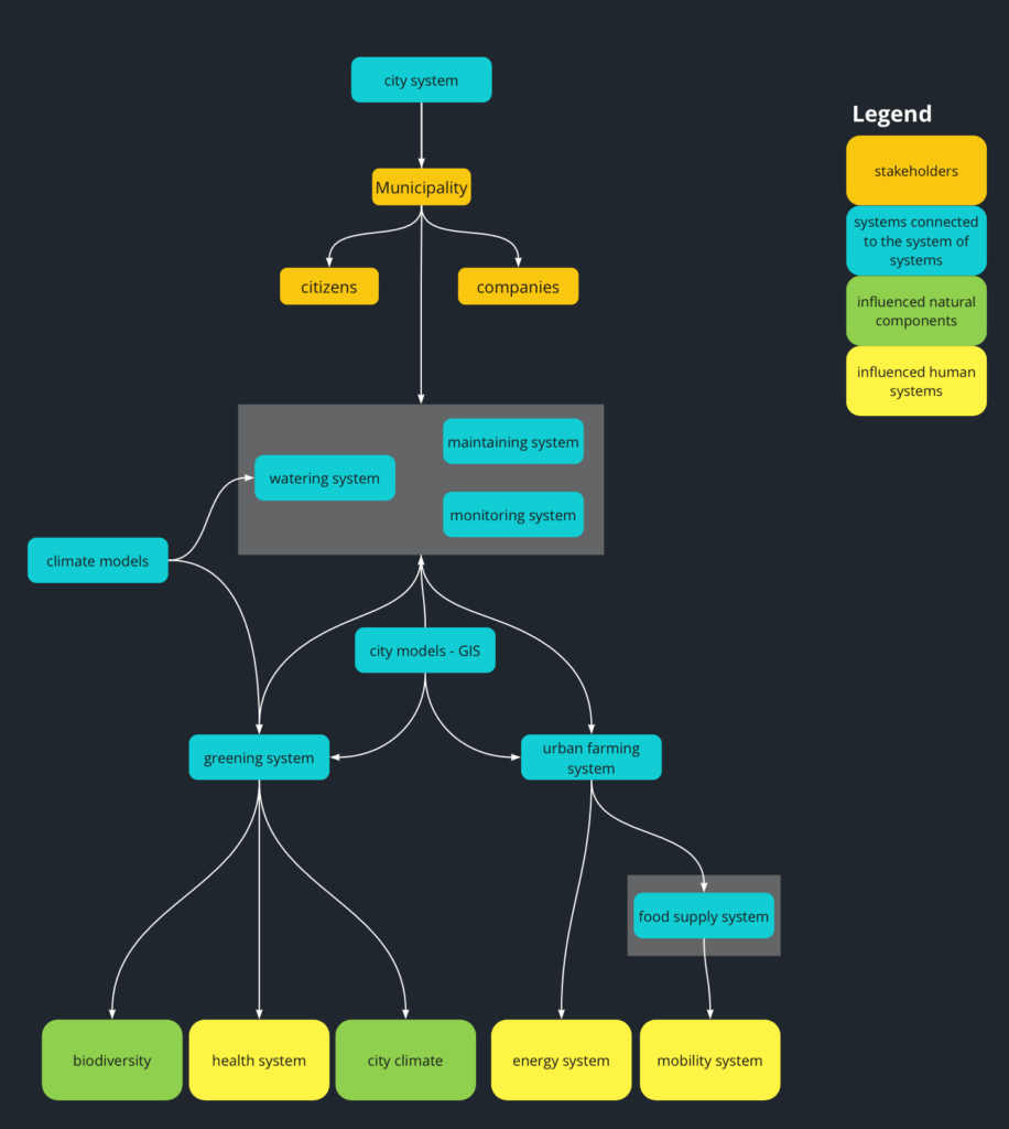
In Figure 1, we provide a high-level view of a possible system of systems within a smart city that uses different interconnected components for the city to adapt to climate change. The introduction of systems of systems in urban contexts poses several unique challenges. Large cities typically have complex structures and many stakeholders who, on the one hand, need to be considered in the design and, on the other hand, are actors themselves that influence the city climate. Furthermore, the land use of each area is predetermined and difficult to change, especially when the goal is to create more green spaces.
To illustrate how a “systems-of-systems” approach allows for greater flexibility, optimization of uses, and multi-use possibilities, one can imagine what would happen if tree plantings or living walls could be easily moved into the existing infrastructure of the city; either autonomously or using autonomous vehicles piloting them through the city. Think of it as a thought experiment that allows us to imagine what the systems of systems would look like, how would the systems interact, etc.
Each movable tree or plant can be seen as a separate system within the “greening system”. Those systems need water and nutrients, which could, for example, be provided by drones (another system), or the movable plants could autonomously drive to a water source they can connect to. Drones could additionally be used as plant keepers (combining the “maintaining system” with the “monitoring system”), meaning that different drones in operation would support the well-being of the plants with a unique set of tasks, or that single drones would be equipped with multiple capabilities to adapt to the plants’ needs by providing water and nutrients, cut the plants, etc. Using sensor data and an image analysis system connected to the system of systems, such drones would be able to directly analyze whether and where plants need to be cut. This approach would minimize the use of resources needed for caretaking (as “management system”) because the drones would only need to act when a plant has a particular care need (as determined by the “monitoring system”).
To assure an efficient and safe route for the autonomous vehicles used for movable plants, connecting a traffic control system would enable the movable trees to autonomously organize their routes. Geographic information systems (GIS) connected to the system of systems would support climate modeling in order to identify areas that could benefit from altering the land use and provide real-time information such as street maps for the moving plants, land use maps to identify free areas where the plants can go, or information on the water infrastructure. If a climate system is added, the plants could be moved to locations where they would positively influence the city climate during the day. For example, they could be placed strategically to provide shade in locations that are prone to the formation of heat islands. GIS systems connected to different sensors providing information could help to identify whether there is a positive impact or not. These connected systems would furthermore have a direct and indirect impact on other systems, for example on the health system, by promoting cleaner air and reducing temperatures, or on the city climate system overall.
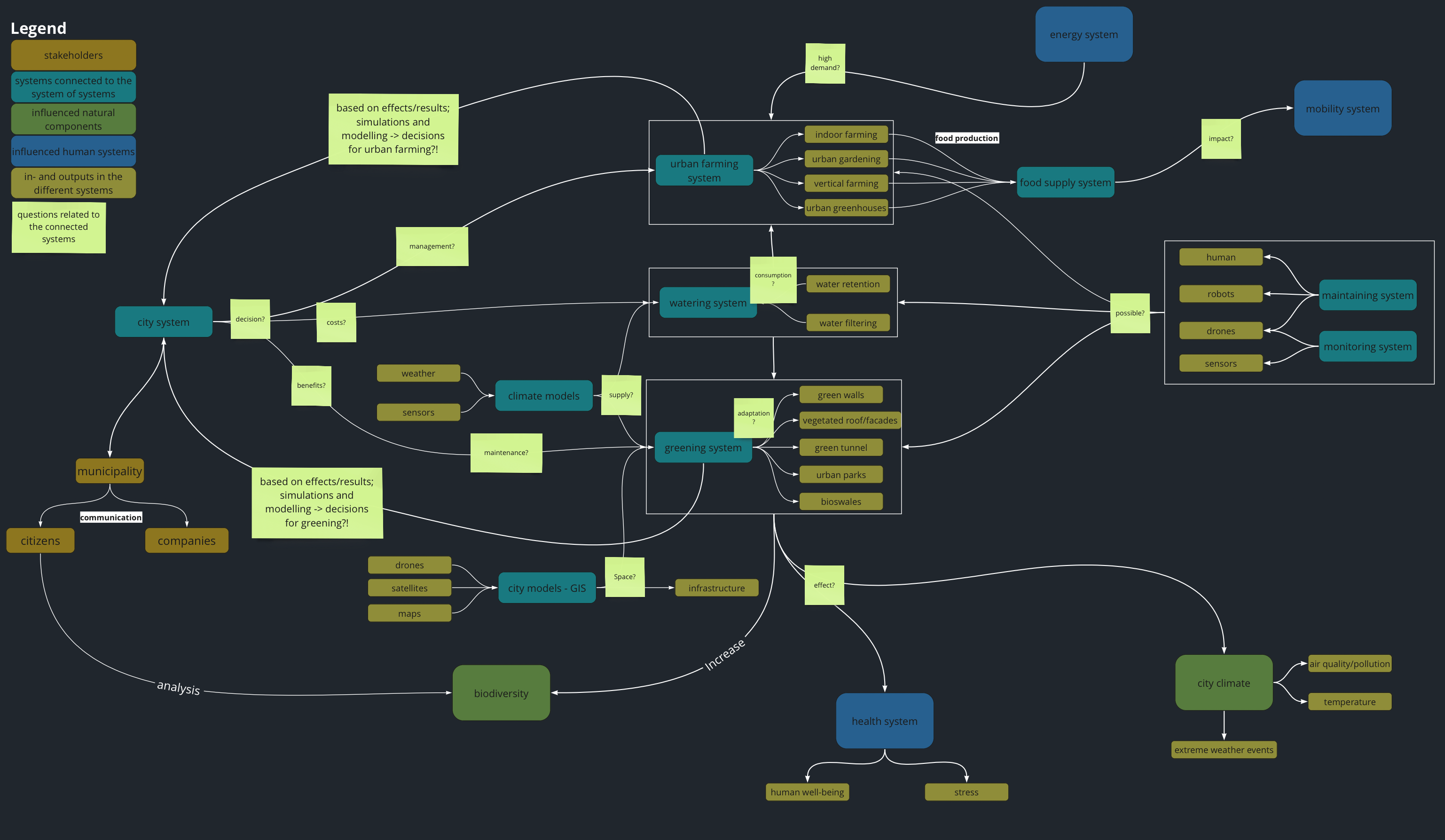
Figure 2 presents a comprehensive overview of possible components and purposes of an urban system of systems. Connecting the different systems mentioned above makes it possible to get a good overview of the city and its traffic, climate, and land use. It provides a more detailed view of a city system of systems to which several additional components were added that serve as inputs and outputs of the various systems it contains. It also provides questions at relevant edges that are important to consider. For example, if a city decides to emphasize green infrastructure, how can they maintain it? What are the benefits of greening? How can greening systems and urban farming systems be managed? How much resources do the plants consume? What effects does the green infrastructure have on other systems? To help answer such questions, this detailed view shows how such systems are naturally connected in a city, and that taking a system-of-systems approach helps visualize and manage this complex network of interacting systems.
Practical examples
At this point, let’s consider two example use cases to illustrate the use of systems of systems in an urban context with tangible examples that demonstrate that this is not just an abstract vision. In this section, we will explore what it entails to put the systems-of-systems approach into practice, what the communication needs are, and how several systems can collaborate in context.
Example use case 1: “Temporary Forest”
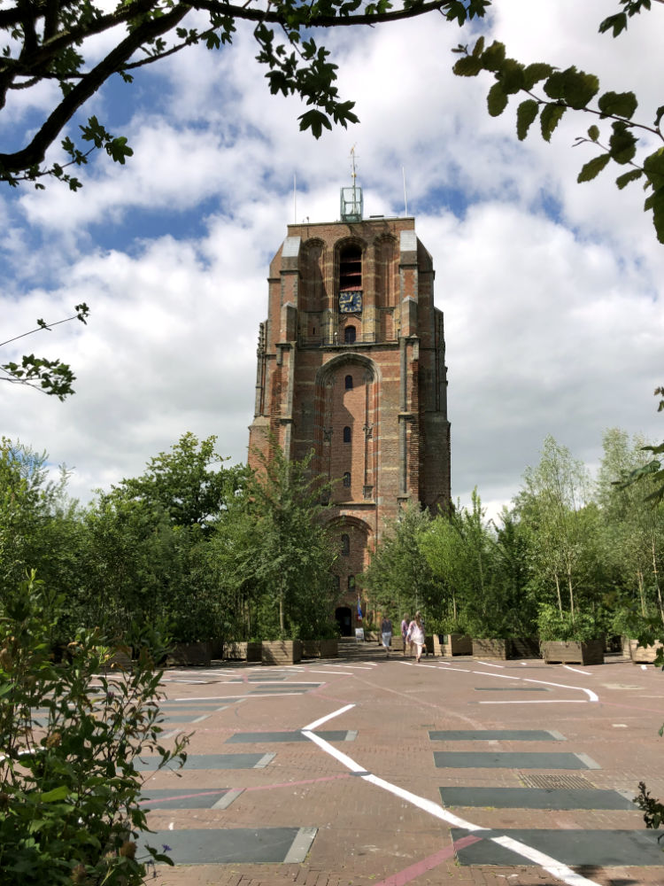
We will first explore an example of putting a market square to good use on the weekends. Similar projects already exist, like “BOSK” in Leeuwarden in the Netherlands, although they do not necessarily use automated systems.
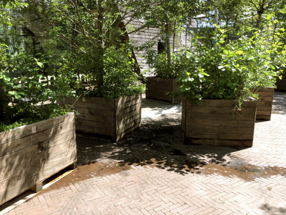
In the summer season, every weekend, a market square is transformed into a small forest by adding trees, moss surfaces, flowerpots, and urban furniture like benches. This “temporary forest” is then used for recreational purposes (e.g., leisure, sports) and sometimes events are organized (concerts, expositions).
At the beginning of the “forest season”, moveable trees, plants, and urban furniture are stored near the marketplace, with some of them possibly even lining nearby streets and fields.
The transformation starts on Friday evening. Trees and plants are moved onto the square by pallet pullers and forklifts. At other times, this group of systems, which is owned partly by the city and partly by a private company, is generally used for logistical tasks.
The configuration of where the trees and plants are placed on the square changes every weekend and is simulated in advance. The goal is to produce enough shade or to place the trees and plants together close enough to locally reduce the temperature while still leaving enough space for people to move around. This information is communicated to the “transportation systems” through the city’s information exchange platform.
On Sunday evening, the trees and plants are brought back to their original locations or to some other place where they are needed.
In order to choose which trees and plants are suitable for the temporary forest in the city, information about the green systems is required: size, weights, shade potential, health status, location, whether a plant is available for the season or is planned for a different purpose with higher priority. Constraints such as transport logistics apply (i.e., can the tree be transported, are there any transport restrictions such as tunnels or electric lines), and these should be managed automatically. This also requires information such as transportation maps and relevant regulations. Crucial information for correctly planning each weekend’s transformation include the shape of the market square as well as the type of events organized during the summer season.
While the temporary forest is there, other things are also monitored, such as local air quality, temperature, number of people on the square, and, more globally, its impact on local businesses and city life. This information is then used to assess the impact of the temporary forest on both its local environment and the city as a whole.
Example use case 2: “Rain events in dry summers”
Our second use case concerns rainwater harvesting on a system-wide level in times of drought. Here we assume that appropriate climate adaptation and water management strategies have already been put in place, and that many of the systems involved can communicate and collaborate over a common digital platform. This use case is not intended to provide a solution to the complex problem of water resource optimization, but rather to showcase the potential of such systems of systems and to highlight the underlying challenges for software engineering.
The weather forecast announces significant rainfall over the city around 4:15 pm. In previous weeks, summer temperatures were high and the soil sensors indicate very dry soil conditions. In addition, the water company has announced that both the public and private water reserves are running low. The possibility to pump up potable water from the ground is limited due to the continuing drought. In this situation, it is crucial to capture as much rainwater as possible to fill the water reservoirs, but also to avoid surface runoff.
Based on the forecasted rainfall and information from the city’s GIS system, the digital rainwater harvesting optimization service calculates the potential to harvest rain per area. The rainwater harvesting potential of each building (e.g., its roof surface), the available storage potential, as well as the amount of rainwater discharged into the street are updated with information from the cadastral digital register and private smart water storage systems.
This information, along with historical data from previous heavy rainfalls, is used as input for a city-wide stormwater simulation to determine which streets and locations are most likely to be impacted by excess runoff water.
he model-based predictions are communicated to the city’s mobility system to decide whether streets or squares should be closed temporarily to avoid accidents. The information is also automatically propagated to the relevant systems, such as the city’s emergency response systems (of the fire department, the police, etc.). The information is furthermore used by the sewer infrastructure department to determine the most efficient way to control and process the upcoming water flow and potentially redirect water to certain reservoirs.
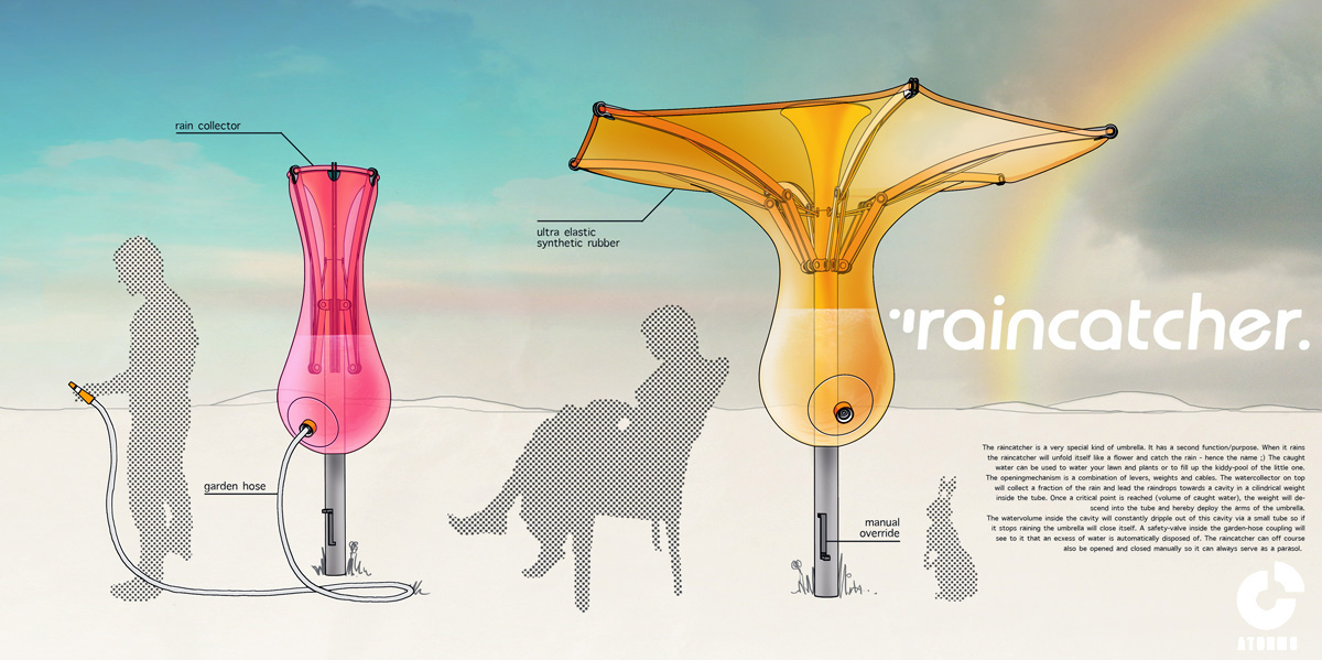
In addition to these fixed systems and infrastructure, it is possible to use systems that collect and filter rainwater at selected points in the cities, like market squares or parking lots. For example, rainwater-catching systems exist that look like upside-down umbrellas (see Figure 3). They usually provide shade on squares, parks, or restaurant terraces. When it rains, they can be unfolded to collect the water, with some models even providing a built-in smart tank. Longer-term measures are also conceivable, such as the planning and creation of temporary water gardens (e.g., in empty parking lots) where any surplus water is redirected. Special tree planters with water connection pipes as well as smart water tanks can also be interconnected to create a circuit of water and plants that will absorb some of the water directly and filter the rest.
Challenges for dynamic systems of systems
The examples above show how facilitating the interaction between different, relatively independent systems makes it possible to solve complex urban problems. However, the design, construction, and maintenance of such software-intensive systems of systems is not without challenges. In the context of the DynaSoS project, we interviewed several smart city experts from cities, research, and industry. Below, we provide a condensed overview of the software engineering challenges that were often cited by these experts.
Communication and interoperability
Smart systems are already in place, and data in cities is already being collected and stored. But breaking up existing silos is often a challenge, and knowing where the information is, what format it has, and what its quality is still poses great difficulty. In addition, since data is being collected for one purpose and then made available to be reused for another, issues of data preparation and quality arise. Accordingly, data exchange platforms need to enable information retrieval, manage associated metadata, and allow the interaction of different systems through standardized interfaces.
Enabling communication, transparency, and new services
The development of urban data platforms goes hand in hand with new adjacent functionalities, such as the introduction of new services using the existing data, or access to new types of information. On the one hand, this is hindered by technical challenges, such as the need to establish common vocabularies and semantics. On the other hand, it enables access to data about the long-term actions taken by a municipality, which can be analyzed and used to strengthen the involvement of citizens and boost communication with them. In this way, improved transparency helps citizens to understand the municipal decisions and processes better.
Quality aspects
Automated interaction and collaboration of different systems that can share simulations and data help to support more evidence-based decision-making processes. This leads to important questions such as: What does quality mean in such a complex system? Does it pertain to the quality of the constituent systems, or to the quality of the system as a whole? And if so, how should it be measured? Who should define the metrics? This in turn raises technical and non-technical issues, from software to regulations and laws to data analysis and social impacts. Therefore, many skills and disciplines need to be brought together, with communication between stakeholders being crucial.
The role of data and learning systems
A good data basis paves the way for good analyses. Data management, quality assurance, and governance are becoming an integral part of a system of system´s duties. Furthermore, the increased usage of data-driven software components that rely on techniques such as data mining or machine learning imposes numerous novel issues on software engineering, including, but not limited to, topics such as model testing, explainability of artificial intelligence components, configuration management, etc. (Martínez-Fernández 2022).
Virtualization and simulation
Urban planning – whether for long-term climate adaptation measures such as new blue/green infrastructures or short-term, local, adaptive, and ephemeral measures such as mobilizing street furniture for specific events – requires predictive capabilities for several aspects, like mobility, buildings, subterranean infrastructure (water, electricity, gas), local climate, etc. For each of these aspects, models must be created – either by experts or based on historical data. The existing models must then be coupled and simulated together to create a sufficiently realistic simulation. Furthermore, the actions suggested by the analysis results can be taken automatically by changing the configuration of the systems or triggering functionalities in the physical world (e.g., through digital twins).
Finally, the complex flow of interactions that exist in these systems of systems must be evaluated, predicted, and controlled. Here, the systems engineering approach to handling complexity, coupled with numerical tools such as data exchange platforms, simulations, and numerical twins, has the power to make the inherent complexity of these systems concrete and help control unintended emergent effects.
References
Gorod, A., Sauser, B., & Boardman, J. (2008). System-of-systems engineering management: A review of modern history and a path forward. IEEE Systems Journal, 2(4), 484-499. DOI: 10.1109/JSYST.2008.2007163
Koch, M., Krohmer, D., Naab, M., Rost, D., & Trapp, M. (2022). A matter of definition: Criteria for digital ecosystems. Digital Business, 100027. DOI: 10.1016/j.digbus.2022.100027
Martínez-Fernández, S., Bogner, J., Franch, X., Oriol, M., Siebert, J., Trendowicz, A., Vollmer, A. M., & Wagner, S. (2022). Software engineering for AI-based systems: A Survey. ACM Transactions on Software Engineering and Methodology, 31(2), Article 37e (April 2022), 59 pages. DOI: 10.1145/3487043
Valcke, T. (2022). ATOHMS projects. [Online]. Available at: https://atohms.wordpress.com/projects/raincatcher/
Titelbild: © Arcansél – stock.adobe.com, BOSK: © Eddy Groen